
Fichier:Central African Republic sub-prefectures.png

Taille de cet aperçu : 800 × 486 pixels. Autres résolutions : 320 × 194 pixels | 640 × 389 pixels | 1 025 × 623 pixels.
Fichier d’origine (1 025 × 623 pixels, taille du fichier : 19 kio, type MIME : image/png)

|
This map has been uploaded by Electionworld from en.wikipedia.org to enable the |
Description
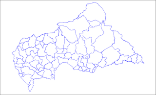
Map of the sub-prefectures of the Central African Republic. Created by Rarelibra 17:58, 31 March 2006 (UTC) for public domain use. Created using MapInfo Professional v7.5 and various mapping resources.
Conditions d’utilisation
| Moi, propriétaire des droits d’auteur sur cette œuvre, la place dans le domaine public. Ceci s'applique dans le monde entier. Dans certains pays, ceci peut ne pas être possible ; dans ce cas : J’accorde à toute personne le droit d’utiliser cette œuvre dans n’importe quel but, sans aucune condition, sauf celles requises par la loi. |
Akota tënë ti yâ ti ambeti
Cliquer sur une date et heure pour voir le fichier tel qu'il était à ce moment-là.
| Date et heure | Vignette | Dimensions | Utilisateur | Commentaire | |
|---|---|---|---|---|---|
| actuel | 3 Föndo 2022 à 09:36 | | 1 025 × 623 (19 kio) | Borysk5 | Blue color |
| 2 Föndo 2022 à 17:39 |  | 1 025 × 624 (20 kio) | Borysk5 | Updated map | |
| 27 Nabändüru 2006 à 19:19 |  | 1 025 × 624 (18 kio) | Electionworld | {{ew|en|Rarelibra}} == Summary == Map of the sub-prefectures of the Central African Republic. Created by Rarelibra 17:58, 31 March 2006 (UTC) for public domain use. Created using MapInfo Professional v7.5 and various mapping resources. |
Utilisation du fichier
La page suivante utilise ce fichier :
Usage global du fichier
Les autres wikis suivants utilisent ce fichier :
- Sara ngô kusala na ca.wikipedia.org
- Sara ngô kusala na cs.wikipedia.org
- Sara ngô kusala na en.wikipedia.org
- Bangui
- Mobaye
- Bria, Central African Republic
- Obo
- Sibut
- Mbaïki
- Bambari
- Kaga-Bandoro
- Bangassou
- Bouar
- Berbérati
- N'Délé
- Kabo
- Alindao
- Batangafo
- Baoro
- Bimbo, Central African Republic
- Birao
- Boali
- Bossangoa
- Bozoum
- Boda, Lobaye
- Bouca
- Damara, Central African Republic
- Carnot, Central African Republic
- Nola, Central African Republic
- Rafaï
- Mongoumba
- Ouadda
- Ippy
- Kouango
- Kembé
- Paoua
- Gamboula
- Sub-prefectures of the Central African Republic
- User talk:Rarelibra/Maps2
- Bakouma
- Bocaranga
- Ouanda Djallé
- Grimari
- Baboua, Central African Republic
- Bamingui
- Yalinga
- Zemio
- Djemah
- Template:Sub-prefectures of the Central African Republic
- Mingala
- Dekoa
Voir davantage sur l’utilisation globale de ce fichier.